Professor Peifeng Ma has been awarded a funding of totally HK$7,210,500 for the project “Development of InSAR Deformation Analysis Technologies for Urban Infrastructural Safety Diagnosis (面向城市建築結構安全診斷的InSAR形變分析方法研發)" under the Innovation and Technology Fund (ITF), from 15 November 2020 to 14 November 2022.
This project aims to develop cutting-edge synthetic aperture radar (SAR) interferometry (InSAR) technologies to effectively diagnose urban infrastructural safety, and establish “ Urban Infrastructural Safety-Oriented InSAR Cloud Computation System”. The objectives of this project include: (i) develop a new generation of distributed scatterer (DS) InSAR algorithm to enhance detection probability of low-coherence points (e.g., flat roof, roads and vegetation) in SAR images; (ii) mine deformation patterns by deep learning of time-series deformation and identify infrastructural safety levels based on National Building Safety Standard; (iii) develop cloud computation systems to improve computational efficiency, especially when processing massive satellite images over large areas; (iv) develop three-dimensional (3D) visualization engines to demonstrate the results more vividly and improve the interface friendliness. The deliverables of this project will fill this gap and open a new window for remote sensing applications, and provide professional services for building managers, government departments, educational institutions, private companies, and etc.
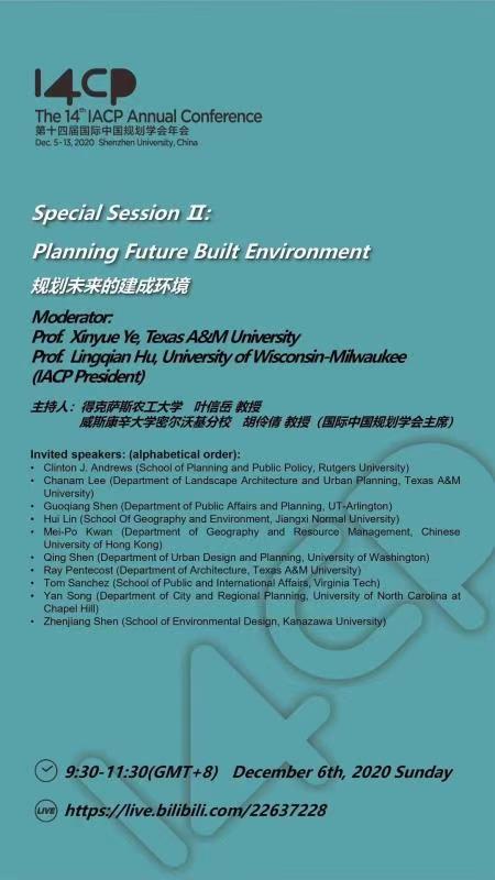
Prof. Mei-Po Kwan will present a report at The 14th IACP Annual Conference Special Session II: Planning Future Built Environment on December 6, 2020 Beijing time.
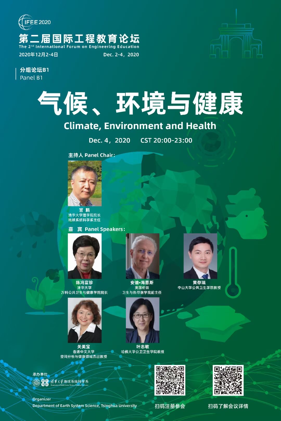
Prof. Mei-Po Kwan will present a report at The 2nd International Forum on Engineering Education Panel B1 at 20:55 on December 4, 2020 Beijing time.
The Guangdong-Hong Kong-Macao Space Science and Technology Alliance held online meeting on 25 October. Representatives of alliance member institutions, specialists and scholars in space science and technology were invited to join the meeting. Professor Kwan Mei Po, Director of the Institute of Space and Earth Information Science (ISEIS) of The Chinese University of Hong Kong (CUHK) participated in the meeting and give a plenary talk on behalf of CUHK as alliance member institution.
Professor Kwan delivered her talk titled "Application of Geospatial Information Smart Technology in Building of Healthy Cities". The talk focused on environmental disaster perception and emergency management that Guangdong, Hong Kong and Macao are facing, and the need of building healthy cities. She also introduced the collaborations between ISEIS and research institutions in the Guangdong-Hong Kong-Macao Greater Bay Area such as Shenzhen Institute of Advanced Technology and Sun Yat-sen University (SYSU).
The Guangdong-Hong Kong-Macao Space Science and Technology Alliance was established in December 2018, in order to enhance the cooperation and to promote in-depth cooperation of space science and technology among the research institutions in the Guangdong-Hong Kong-Macao Greater Bay Area.
粤港澳空间科学与技术联盟拟于2020年10月25日举办线上交流,以推动湾区高校及科研机构在空间科学、空间技术等领域的深度合作,详细内容请参考附件。
香港中文大学(中大)太空与地球信息科学研究所(太空所)马培峰博士团队作为第二申请者获得中国测绘学会2020年测绘科学技术一等奖(详情请见:http://www.csgpc.org/bencandy.php?fid=108&id=6892),这是香港中文大学首次获得测绘科技进步奖。
马博士团队参与的获奖项目“重大基础设施形变雷达遥感监测关键技术与示范应用”旨在利用卫星遥感技术监测国家重大基础设施形变,该技术类似于医学上的CT扫描技术,可对城市基础设施(如公路、铁路、大坝、桥梁、楼房、机场)进行大范围扫描并提取形变信息,其精度可以达到毫米级,用于基础设施结构健康诊断。
他认为这次成功有赖于中大所提供的专业训练,在多个ITF和RGC项目支持下,把理论研究和应用实践相结合,并在顶级学术期刊上发表文章。他也特别感谢太空所所长关美宝教授的推荐和太空所提供的开放学术环境,让他有很大的自由度和发挥空间,得以专心从事研究工作。中大太空所具有的接收世界一流雷达卫星数据的能力也是此次获奖的关键。
测绘科技进步奖主要奖励在我国测绘科学研究、技术创新与开发、科技成果推广应用、高新技术产业化以及重大工程管理实施等方面做出突出贡献的项目、单位及个人。本年度测绘科技进步奖共收到全国240多份申请书,最终2个项目获得特等奖,22个项目获得一等奖。
Title: Tracking Movement through Space during COVID-19 and beyond.
Time: Sept 8th at 9am ET, 9pm Beijing time
Organized by: Location Tech Task Force, EthicalGEO, American Geographical Society
Sponsored by: Henry Luce Foundation
Registration required. More information at:
https://ethicalgeo.org/event/tracking-movement-through-space-during-covid-19-and-beyond/
Harvard CGA Virtual Forum: Responding to the COVID-19 Pandemic with Geospatial Research and Applications
As the COVID-19 pandemic evolves rapidly around the globe, Harvard's Center for Geographic Analysis (CGA) will hold a virtual forum on time-sensitive geospatial research and applications for COVID-19, on May 1, 2020, from 10:00am to 1:00pm EDT.
April 6th - 12:30 PM / 2:00 PM (MDT) - vimeo.com/live-chat/404110758
Description: Reactive policies to manage the rapid spread of the COVID-19 pandemic has had wide-ranging impacts on the social and economic burdens faced by populations worldwide. This panel will discuss the disproportionate impacts of COVID-19 on economic and public health outcomes.
Participants:
Dr. Irene Casas (Lousiana Tech University)
Dr. Joseph Oppong (University of North Texas)
Dr. Jessica Finlay (University of Michigan)
Dr. Jung Won Sonn (University College London)
Dr. Eric Carter (Macalester College)
Dr. Michael Emch (University of North Carolina at Chapel Hill)
Dr. Michael Widener (University of Toronto)
Moderator: Dr. Chetan Tiwari (University of North Texas)
April 10th - 8:00 AM / 9:30 AM (MDT) - Join Virtual Session
Description: Geographers and spatial scientists can play a vital role in understanding COVID-19. However, current research is likely to be data driven due to the fluidity of the pandemic. This panel will discuss the data and methodological challenges that we currently face in spatially-explicitly studies of COVID-19.
MORE
Participants:
Dr. Mei-Po Kwan (Chinese University of Hong Kong)
Dr. Michael Desjardins (Johns Hopkins University)
Dr. Xun Shi (Dartmouth College)
Dr. Meifang Li (Dartmouth College)
Dr. Eric Delmelle (University of North Carolina at Charlotte)
Dr. Tzai-Hung Wen (National Taiwan University)
Moderator: Dr. Chetan Tiwari (University of North Texas)